Lakewood Informer

Resident generated news about Lakewood, Colorado

Lakewood Informer

Resident generated news about Lakewood, Colorado

Development

What Is the Government Solution to Homeless

Lakewood residents reach out for a government solution to homeless encampments, as written about on kdvr.com by Alliyah Sims. Lakewood says encampments like these are the reason to open more shelters and offer more resources. But not everyone takes the resources offered. The problem, as noted in the article, is that these encampments (not all) are located in an area that caters to homeless. Lakewood’s Navigation Center is half a mile away, the Action Center less than a mile away, outpatient services near this encampment at 14th and Vance, and others close by. But what if the unhoused do not want the resources provided? Governments can force taxpayers to provide resources but they can’t force people to utilize them as intended. Lakewood police say help has been offered but not often accepted. As the author of San Fransicko wrote, ““Homeless is a propaganda word” because it also describes the open-drug scene. Because when you say homeless you think it’s a housing problem and people who only have housing problems are the easiest populations to help. The overwhelming problem with the homeless is street addiction and untreated mental health crises.”  – Michael Shellenberger Cities like San Francisco and Denver have been experimenting with government solutions but the only continuing metric of success is the amount of people served and money spent. The increasing number of homeless in these cities is disregarded as irrelevant. From kdvr.com: “Neighbors living in Lakewood are calling for the city to come up with a permanent solution to homeless encampments popping up in their neighborhoods. “They say the sites near 14th Avenue and Vance Street have been a problem within the last year, but they have seen it grow with the recent cleanup at the 6th Avenue and Wadsworth Boulevard interchange that happened last week.‘Long time coming’: Lakewood homeless encampment cleared “Lakewood police say while they are aware of the camp, they can not confirm if it’s the same people from the 6th and Wadsworth clean-up. “They say they offered help to everyone living there, but a lot of times it’s just not accepted, creating an endless cycle. “I’ve been at this location for almost 10 years now, and we love the work we do and love helping others,” said Marie Archambault.” Read the full article….

Rezoning affects Milestone Property

By Russha Knauer, Cross-post with permission from nextdoor.com, The upcoming Rezoning Ordinance meeting is being held on Wednesday evening at 7pm at 480 S Allison Pkwy. This meeting will cover several rezoning issues. If you live in the area of Kipling and Alameda or Alameda and Garrison, this meeting will be especially important for you to submit public comments or attend and make your voices heard. Find information about the meeting and how to submit public comment here: https://lakewoodspeaks.org/items/4256. Specifically, the zoning ordinance updates will allow for the land along Alameda and Kipling informally known as the Milestone Property to be rezoned to allow for high-density, mixed use urban development. That means that high-rise, high-density development up to 96′ can be developed. This will go against the current zoning and surrounding development of the area. There are several things that are important to know about this rezoning proposal. First, the rezoning proposal was included in the non-residential zoning map, so many people are unaware that this could happen and how it could directly affect them. Second, this is one of two properties slated for rezoning in this manner; the second is already developed and the rezoning ensures the current development is allowable within zoning regulations. Third, the city stated that the Milestone property is one of 10 “difficult to develop within current zoning regulations” pieces of property. To be clear, this land is currently zoned to be developed as single family homes with mixed commercial use on the corner of Alameda and Kipling. However, the developers have fought the neighborhood for two decades to rezone the property to allow for high-density development. The only thing difficult about developing this land is the developers, not the zoning. Fourth, the city planning department recently told the Planning Commission in a meeting on 4/9 that the implementation of “Envision 2040” is the “city’s”, meaning there is no duty for the City to engage neighborhoods when development or re-development is proposed. Further, the city’s planning department stated in a presentation on 4/18 that going forward, developers will be the ones who have the option to engage neighborhoods when development is proposed, further abdicating the City of their role in engaging neighborhoods. Finally, the City has made this information difficult to understand and find when it comes to identifying nuanced information and how it will affect specific areas and neighborhoods. Please come and make your voices heard! Make sure the City knows that developers should not be valued more than tax-paying residents; that the City has a duty to engage neighborhoods when development is proposed; and that rezoning should not be allowable in plans that are difficult to understand and provide no clear forewarning to affected areas.

Toxic Legacy: Uncovering the Chemical Contamination at the Denver Federal Center – Part 3: The Bend Project and the City’s Blight of Transparency

By Karen Gordey See Part 1 and Part 2 for more background The Lakewood Planning Commission met on January 22, 2025; the day after the West Metro Fire Department Board of Director meeting.   During this meeting, Anne Ricker from Ricker Cunningham presented “The Bend” to the Planning Commission.  Commission Kolkmeier stated, “Just note for folks, listening and reminder to commissions and folks in attendance today that this is an unusual matter that comes before us.  We don’t typically get asked to make a recommendation as it relates to compliance the comprehensive plan on an urban renewal project.  But it is pretty straightforward.  The specific question that we will be discussing today is whether or not the proposal that is presented is in compliance with the comprehensive plan already adopted by the city of Lakewood.  That is the current plan, not the next plan that is still in process.” The documents (located on Lakewood Speaks) provided to the Planning Commission were the following: Where is the Blight Report also known as a Conditions Survey? Why does the Lakewood Planning Commission not know what the actual approval process for Urban Renewal project is?  The blight survey, while mentioned in the presentation, was not presented separately to the Planning Commission.    On February 3rd, I submitted a CORA request and subsequently received the blight report.   It is a 42 page document.  The closest document (shown above) would be the first one titled, “9.11.24 The Bend @ Lakewood Urban Renewal Plan revised 12.30.24 corrected 1.8.2025.  However, that document is only 32 pages and is missing the following pertinent information (and therefore is not the Blight Report/Conditions Survey): The Phase 1 Environmental Site Assessment Environmental remediation Institutional Controls CDPHE findings Any land use restrictions Red Flags in the Blight Report Here are just a few of the inconsistencies: Feel free to look over both documents using this link:  https://drive.google.com/drive/folders/1O0eNIOLdCo833C0xGKrvvRAeH9sUeVez and ask yourself why would this type of pertinent information be omitted from the public documents. Is This Really “Blighted”? Because the property is predominantly open land, the statute requires at least 5 out of 11 blight factors to justify a designation. The planning commission presentation claims the land meets 9 out of 11.  A striking figure, considering the area’s size and federal legacy.  The City Council has yet to vote this as a new urban renewal project so it is not yet officially blighted. Additionally, the deed and the developer both mention an underground storage tank that leaked VOCS and MTBE.  However, do we know where this underground storage tank was located on the DFC?  Historical government documents tell a different story.  They reference TCA, TCE, DCE and never mention MTBE.  Building number at the Denver Federal Center changed over time, so: is the tank even in the location cited?  Is it the same tank? (Editors note: You can research underground storage tank locations at the EPA website) If the full report acknowledges multiple land use restrictions, how did the Lakewood Planning Department approve this development, phased or otherwise? The Missing Piece: Where’s the GAP Analysis? The gap analysis is supposed to justify public financing tools like TIFs. It reveals whether costs; such as contaminated land, demolition, or regional infrastructure make a project financially unfeasible without help. But in this case, no gap analysis exists.  A Colorado Open Records Act (CORA) request was made.  Below you can see the response from the city of Lakewood. This is especially alarming because contamination at the DFC is well documented – and (contamination) has even been used to justify TIFs in other cities (like Castle Rock and the Gates property at Broadway & I-25).  Additionally, I am not sure why the Lakewood Planning Department would think the Federal Government would do a gap analysis on private property for a potential Lakewood Urban Renewal project. Finally, one final question is what portion of the land is the development planning on giving the city for parkland dedication?   Per the latest ordinance, hazardous land cannot be given to the city.  This means that the landfill area with the “no ground disturbance restrictions” cannot be dedicated for parkland.  Yet another reason to do a gap analysis to determine what amount of money this will cost the developer, city, taxpayers etc. Water Woes: The Lawsuit You Should Know About Lincoln Properties has been trying to obtain a commitment to water and sewer service from the Green Mountain Water Board (GMWSD)  since approximately July 6, 2023.  Because a decision has not been made, Lincoln Properties has filed a lawsuit against the Green Mountain Water Board.  In court filings from Jefferson County District Court, Lincoln claims that the district has withheld service, or at least failed to act, on its application for water and sewer hookups since July 6, 2023. GMWSD did receive a 74 page environmental report from Trihydro in August of 2024. However, no new testing has been conducted since the board could not decide how to proceed, including no testing for the 26 chemicals in the consent decrees.  I attended the April 8, 2025 board meeting and spoke during public comment.  In short, I explained I am not anti-growth but rather I am for common sense growth.  Lakewood will not go back to being the bedroom community we were years ago.  The northern piece of the property has a build restriction and the entire property has a groundwater restriction. There are additional questions that need to be answered: It will be interesting to see how the GMWSD court case plays out.  City Council is meeting on this topic during a study session on April 21, 2025 which is a virtual meeting.  Per the agenda and the accompanying materials, they will be learning about metro districts and TIFS.  Additionally, the builder is seeking guidance from the city on availability of sewer services from the city.   How much is that going to cost the taxpayers of Lakewood? As you can see, there are a lot of unanswered questions that need to be answered.  Maybe

Toxic Legacy: Uncovering the Chemical Contamination at the Denver Federal Center – Part 2: Blight or Oversight? The Bend, the LRA, and Lakewood’s Shortcut

By Karen Gordey “Transparency isn’t optional when taxpayer dollars and contaminated land are involved.” A New Name, A Familiar Pattern Most Lakewood residents haven’t heard of “The Bend.” That’s because it was previously known in city discussions as the 6th & Union, 4th & Union, or simply part of the Denver Federal Center redevelopment. To longtime residents of Lakewood, it is known as the Horseshoe Property. It quietly rebranded, and with it came an expedited process that skirted public scrutiny. I attended a West Metro Fire Protection District Board meeting on January 21, 2025, out of concern for wildfire readiness. What I stumbled into instead was a vote on tax increment financing (TIFs) for a development I’d never heard of—The Bend—on land I knew all too well. As a result of hearing this, I went out to the Lakewood website to refresh my memory on the Lakewood Reinvestment Authority (LRA). From the Lakewood website: “The fundamental mission of the Lakewood Reinvestment Authority (LRA) is to encourage private reinvestment within targeted areas of Lakewood. The LRA has been created by citizens to enhance the City’s ability to preserve and restore the vitality and quality of life in the community.” So let’s first look at how the Lakewood Reinvestment Authority (LRA) process is supposed to work. (Below is a bullet point version. However if you are interested in seeing the full presentation it is on Lakewood Speaks and you can search for the LRA meeting from March 4, 2024.) Lakewood’s Reinvestment Authority (LRA) process, aligned with Colorado state law, outlines a clear and deliberate path for redevelopment: What Actually Happened with The Bend Sidebar: Past Precedents Lakewood has a documented pattern of fast-tracking redevelopment by combining steps for blight designation and plan approval. For example, consider these past projects: Developer Negotiating TIFs? At the January 21, 2025 West Metro Fire Department Board of Directors meeting, officials explained that they were approached, not by the City but rather by the developer regarding a new urban renewal agreement for the near 6th Avenue and Simms/Union. This land lies within West Metro’s boundaries, but not currently in their response area. The meeting minutes show active negotiations over TIF revenue shares, which should raise eyebrows because the developer has no role in negotiating government taxes. This raises a critical question. Was the developer acting as an agent of Lakewood? Was the developer acting on behalf of a presumed new metropolitan district?  Just weeks later, at the February 18 meeting, the Fire Department approved the TIF Sharing Agreement with the City of Lakewood for the Bend project, again detailing the revenue splits. While both of these documents can be found on the West Metro Fire Department website, both meeting minutes have been downloaded and can be found here on our google drive:  https://drive.google.com/drive/folders/1O0eNIOLdCo833C0xGKrvvRAeH9sUeVez Here’s the problem: under the Colorado Urban Renewal statute  https://colorado.public.law/statutes/crs_31-25-107 developers are not authorized to negotiate Tax Increment Financing (TIF) agreements. That duty lies exclusively with the Urban Renewal Authority (URA) in this case, the Lakewood Reinvestment Authority (LRA) or the City itself, acting in that capacity.  The minutes of West Metro make no mention of negotiating directly with Lakewood. Under the statute section (9.5)(a), the taxing agreements must be worked out with the appropriate entities before the plan is approved but there is no new metropolitan district approved, unless one was promised behind closed doors. Even if a new metro district was granted, there should be a meeting and A VOTE of that Board of Directors, with conflict of interest disclosures filed. In this case, the property owners and developers will likely be the only board members so they will act as their own government. They will negotiate deals as a government that will enrich their personal property in a direct conflict of interest. They will be able to do this legally if Lakewood City  Council approves their service plan in May.  Why It Matters The LRA has extraordinary powers: it can borrow money, sue and be sued, condemn property, and distribute public financing to developers. When oversight is minimized or skipped, or in this case handed over to the developer; transparency, accountability, and public trust suffer. And when that’s happening on top of a Superfund site, it’s not just a process problem, it’s a public health issue and fiscal irresponsibility. Article 3 will dive into the specifics of what’s in the blight report/conditions survey, the gap analysis,  what the city has currently approved for this property, and the lawsuit filed by Lincoln Properties against the Green Mountain Water Board. Please Note, the author did send an email  on April 7th to the Mayor and City Council requesting to talk about this project.  No one has yet to respond. Important Upcoming dates: April 21st at 7 pm – Virtual Study Session with City Council and the Lakewood Reinvestment Authority (LRA) May 8th at 6:30 pm – Screening of the movie “Half Life of Memory, Rockleys Event Center 8555 W Colfax Ave, Lakewood, CO 80215.  This event is free! May 12th at 7 pm – City Council Meeting, 400 S. Allison Parkway, Lakewood, CO, 80226.  7pm  Public Hearing for the 1.) Creation of Urban Renewal District 2.) Creation of Metro District 3.) Approval of parkland dedication, including improvements in-lieu of a site greater than 15 acres.

2 + 2 = … Or doing math the developer boot-licker’s way

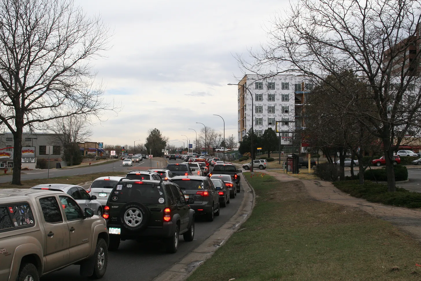
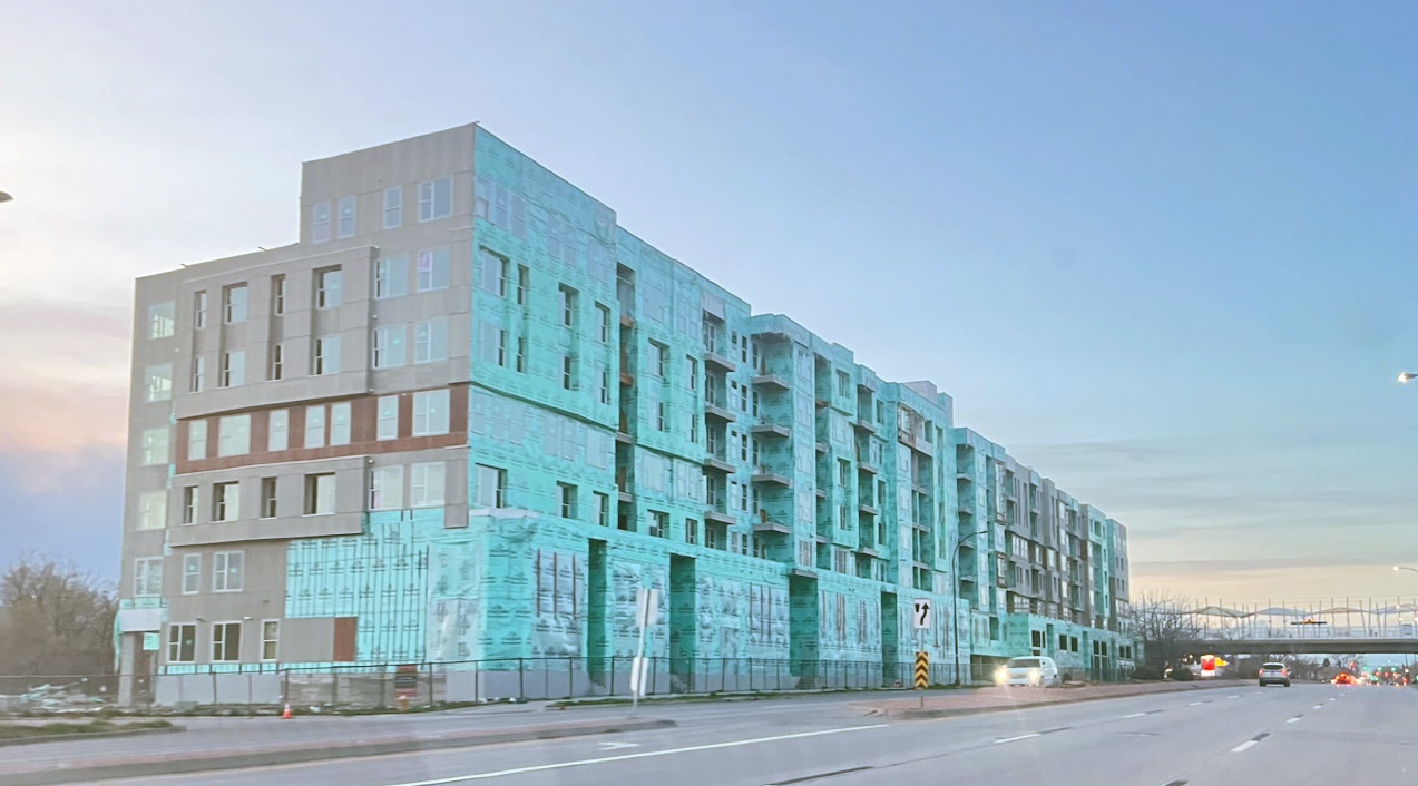
Alex at Somebody Should Do Something posted a lengthy set of articles regarding The Bend development with specific attention to traffic and economic development. Summary: Highlights from Alex at Somebody Should Do Something Part 1 “Environmental injury is often the very definition of irreparable harm — often permanent or at least of long duration,” Arguello wrote. In the latest installment of the “how can a self-proclaimed progressive city council enrich a developer to the detriment of the environment and the community’s well-being”, City of Lakewood is allowing a developer to push forward with a development which will significantly increase traffic on a major thoroughfare, further strain our environment, potentially expose the future residents to toxic hazards AND, again, bring no meaningful economic development to the city. Royal Lakewood Land Partners has made a submission for a development called “The Bend”, situated on the NW corner of the Federal Center, close to the intersection of the 4th Avenue and Union Boulevard, and, just a hop and a skip away from the off and the on-ramp from the 6th Avenue. To add the insult to the many more injuries to come, as shown in the 2007 Master Plan, the site was originally slated for Office Development – a perfect potential use, considering the proximity of the LightRail tracks and the dire need for this city to stoke actual economic development. As usually is the case, the math does not add up. The developer is using the tactic of “here is a traffic study… but it’s only for a part of the development, but we won’t even tell you how many poor souls we want to stuff in to these chicken coops. Then they talk about how this will “hardly” affect traffic, etc. By the time the locals realize just how badly it will have screwed them, the city council and the bureaucrats, who had enabled this environmental and economic disaster, will have moved on to something else, such as being a State Representative, where they continue to shill for the developer profit (ahem, Rebecca Stewart). So, lets see if 2 + 2 equals 4, or, maybe, 17, or maybe a dumpster fire for decades to come. Who knows. The math is very political-contribution-size-dependent these days. Lets look at some of the documents in the submission provided by the developer. 01 – The Bend Minor Subdivision Plat – Traffic Study_2024-10-10 There are only details show for the Southern part of the plat – what about the Northern part of the plat? This is where the math gets hazy, quick. A tactic of piece-mealing the development plans is frequently used (just as is the case with the development near Belmar) to, lets say, omit, the actual impact of the additional car-travel-per-day numbers on the area surrounding the development. Not only will this adversely impact the surrounding area, but also add to the already high total of vehicles having to travel out of Lakewood, since Lakewood has failed to attract localized, high-tech, well-paying employment. Read the rest about environmental and drainage problems at Somebody Should Do Something Part 2 Lakewood (and Colorado at large) are not exactly known for keeping up with building up infrastructure needed to support the additional thousands of people they keep stuffing here. Nor are they known for making the developers pay their fair share for the traffic created, parks overloaded, or the schools needed. However, Lakewood is well known for enabling Metro Districts and the potential resident abuse that comes with them. Of course, there will be a Metro District. Following are some of the snippets from the Metro-District-related documents submitted by the developer for The Bend “The population of the District at build-out is estimated to be approximately 3,350 people, based on a projected number of 2,000 multifamily units and 100,000 square feet of commercial, and a population estimate of 1.5 persons per multifamily unit and 3.5 employees per square foot of commercial property.” So, HOW MANY UNITS WILL THERE BE? And just as was the case with the Red Rocks Ranch, the development might potentially work out as a net negative to the county and the city? The Bend @ Lakewood MD Service Plan Application Memorandum 4875-7617-6597 4 .DOCX “The existing service in the area to be served by the proposed project is inadequate for present and projected needs. There is currently no other jurisdiction or entity, including the City, that considers it feasible or practical to provide the Development with the water, sanitation, street, storm sewer, or other improvements and services described in the Service Plan necessary to serve the anticipated Development. Current services are inadequate, and it is necessary for the District to be organized to provide such Public Improvements and services for the benefit of its future inhabitants.” In fact, there IS sanitation service and fire service and storm-water service. These are all covered by existing city and special districts in which the property is located. However, there is no taxpayer funding for development, and that is what the metro district will provide. And of course, any service provided would have to follow the rules in place, rather than creating their own rules, right? For example – lets look at the Rules and Regulations of one of the nearest Water and Sanitation Districts, Green Mountain Water and Sanitation. Read the rest of Part 2 at Somebody Should Do Something

Toxic Legacy: Uncovering the Chemical Contamination at the Denver Federal Center – Part 1: Beneath the Surface of War, Waste, and What Remains

By Karen Gordey Tucked between Lakewood’s bustling shopping centers and its picturesque parks lies the Denver Federal Center (DFC), a 670-acre campus home to over 25 federal agencies. To most passersby, it’s a secure and efficient government hub. But beneath its streets, buildings, and manicured lawns lies a chemical past that many residents have never been told. What Is a Superfund Site? A Superfund site is a polluted location in the United States that requires a long-term response to clean up hazardous material contaminations. These sites are designated under the Comprehensive Environmental Response, Compensation, and Liability Act (CERCLA), a federal law enacted in 1980. The Environmental Protection Agency (EPA) is responsible for identifying these sites and overseeing cleanup efforts to protect public health and the environment.  The designation of a Superfund site is reserved for the  most severely contaminated properties The DFC earned its Superfund designation in the 1980s due to decades of industrial and military use that left behind a toxic stew of solvents, petroleum products, heavy metals, and polychlorinated biphenyls (PCBs). These contaminants infiltrated the soil and groundwater, some migrating offsite and threatening surrounding communities. What is a Brownfield Site? Brownfield sites are often used for urban renewal projects around the country.  The Denver Federal Center is NOT a brownfield site.  A brownfield site are often industrial or commercial properties (for example, gas stations, dry cleaners, warehouses) where low to moderate contamination from a hazardous substance pollutant or contaminant may exist.  A Wartime Footprint with Lasting Impact Originally established as the Denver Ordnance Plant during World War II, the DFC was a key player in America’s wartime production. The facility once employed over 22,000 workers and churned out more than 6,000 cartridges per day. But the speed and scale of production came with environmental consequences. Manufacturing and testing munitions involved a host of hazardous chemicals. Following the war, the General Services Administration (GSA) took over the site, transitioning it into a campus for multiple federal agencies. Unfortunately, waste disposal practices of the era were primitive by today’s standards. Wastes—including solvents, heavy metals, and PCBs—were buried in landfills scattered across the campus. One particularly damaging leak occurred near Building 52, where an underground storage tank released 1,1,1-trichloroethane (TCA), a solvent used in asphalt testing. The resulting groundwater plume migrated beyond the property’s boundaries, contaminating nearby wells. Cleanup Efforts: Too Little, Too Late? The scope of contamination eventually triggered federal intervention. By the late 1980s, extensive remediation was underway. Crews removed over 775,000 tons of waste and more than 340,000 tons of contaminated soil, particularly from heavily affected areas like Downing Reservoir. While these efforts were substantial, the contamination’s reach and the complexity of groundwater remediation pose lingering concerns. The Denver Federal Center was removed from the Superfund list in 2012 due to clean up measures being concluded.  However, if development is going to be done more testing may be needed. A water permit issued September 1,2022 and expires August 31, 2027.  This allows the DFC to discharge into the McIntyre Gulch entering Lakewood Gulch, which is a tributary to the South Platte River.   There are 8 outflow monitoring points between the DFC and the South Platte River.   The permit does transfer with a sale of the property.  A condition of this permit is to notify the EPA in writing as soon as possible of any planned physical alterations or additions to the permitted facility.  Has this been done?  What happens when the ground is disturbed? Are these chemicals going to go into the water? What about the wind?  How much is this going to cost the Lakewood citizens?  Per the chemistry case study from 1/23/2001, the DFC has a permeable reactive barrier that is a funnel-and-gate system with 4 reactive gates.  Performance of 2 of the gates has been difficult to assess due to trichloroethylene (TCE) and dichloroethylene (DCE) contamination.  In fact there were originally 26 different chemicals found at the DFC of which 12 are known carcinogens (cancer causing).   Has the developer, city, water board tested for these 26 chemicals?  (This link has a list of the 26 chemicals:  https://drive.google.com/drive/folders/1O0eNIOLdCo833C0xGKrvvRAeH9sUeVez ) In the next installment, we’ll shift our attention to the City of Lakewood’s role—specifically the Planning Commission and the Lakewood Reinvestment Authority (LRA)—to explore how land use decisions and redevelopment incentives intersect with environmental concerns at the Denver Federal Center. As public agencies move forward with projects like “The Bend,” it’s critical to examine the transparency, accountability, and long-term implications of these planning processes. Because when contamination meets redevelopment, what you don’t know can hurt you—and the cost of looking the other way may be too high. Please Note, the author did send an email  on April 7th to the Mayor and City Council requesting to talk about this project.  No one has yet to respond. Important Upcoming dates: April 21st at 7pm – Virtual Study Session with City Council and the Lakewood Reinvestment Authority (LRA) May 8th at 6:30 pm – Screening of the movie “Half Life of Memory, Rockleys Event Center 8555 W Colfax Ave, Lakewood, CO 80215 May 12th at 7 pm – City Council Meeting, 400 S. Allison Parkway, Lakewood, CO, 80226.  7pm  Public Hearing for the 1.) Creation of Urban Renewal District 2.) Creation of Metro District 3.) Approval of parkland dedication packing including improvements in-lieu of a site greater than 15 acres.

1221 Wadsworth Update

Update from Council Member Isabel Cruz to Lenore Herskovitz The construction at 1221 – 1225 Wadsworth remains an eyesore that residents constantly question. Councilor Isabel Cruz was kind enough to provide a detailed update to resident Lenore Herskovitz, rather than just referring her to the city website, which has not been updated since October 2024. Update: The new contractor has submitted their forensic report to the City Building Department for review. Three building inspectors completed an initial inspection of the project this week. Based on the reports provided to the City and the information observed during the inspection the building is in better condition than was expected. However, major parts of the fire sprinkler system must be removed and reinstalled, all of the doors and the windows must be removed and replaced, and the wrapping on the exterior of the building must be removed and replaced. The new contractor has agreed to submit and follow a construction waste and demolition plan (not required at the time of the initial approval) which needs to be submitted and approved. In addition, the new contractor still needs to submit new collateral prior to full start up. The contractor is already active in the building but the general public will not notice a significant change in construction activity for 30 to 60 days. I expect a meeting with the contractorn next week to discuss Wadsworth lane closures needed to begin working on the east side of the building. I believe that site security is still being maintained. The contractor has also indicated to me that they may not be able to use the parking area on the school property directly across 12th Ave, in which case they are trying to secure other options. On a side note I requested that the contractor install a sign or banner visible on Wadsworth to signal work has resumed. They have indicated that they are willing to do that as full scale work resumes. Sincerely, Isabel Cruz

Lakewood greenlights Kairoi to introduce invasive plants to BelmarPark

Photo by Regina Hopkins From Savebelmarpark.com In case you are wondering, the Irongate Complex at 777 S Yarrow Street has been converted to rubble by the demolition crew.  Large piles of concrete rubble await removal. Moving on to the topic of the day, a portion of Belmar Park is designated for grading on the developer’s grading plan.  We estimate the area of the park to be graded amounts to thousands of square feet assuming the grading plan mentioned does not change. However, Lakewood’s Planning Department states the opposite: “The proposed development of this property does not involve or include any parkland…” Obviously, any area of the park destroyed by heavy equipment activities related to the Kairoi market-priced housing project will have to be fully restored to original or better condition, right?  Wrong again. According to the Erosion Control Report submitted to Lakewood by Kairoi’s civil engineers, only 70% of a restored area needs to be restored with ‘vegetation visible’ according to p.22.  There is no requirement that the park be fully restored to original or better condition!   Let’s say someone crashed into your parked car and does significant damage.  After body shop repairs, only 70% of the damage is repaired.  Are you OK with that?  If you are, apply for a job at the City of Lakewood where that level of completion is apparently acceptable when it comes to requiring developers to do the right thing. Once an area has been graded, the developer will usually attempt to restore the area. Read the entire newsletter…

Site Plan for the Ex-Superfund Landfill

Thanks to a Lakewood Informer reader and local resident, the site plan for The Bend has been revealed! Contrary to previous reporting, plans have indeed been laid but when discussed in public meetings, those plans were “punted” till later. The north half was not a focus for the City because the planning department granted the developer a phased development status since remediation plans have not been set. Our reader supplied a full list of instructions to access this information online, which were not provided with Lakewood’s CORA response. To view the plans, the public must register with the eTRAKiT site and login. The address associated with the project is 11601 W 2nd Pl. In eTRAKiT, search for the following project numbers: The master plan reveals the area north of 4th Ave that is currently labeled “do not disturb” will eventually have more residential housing than the south end, totaling about 2000, rather than 2000 only on the south end. There is currently no public plan for remediation or start times while the developer, Lincoln Properties, works to secure the pieces necessary to get a metropolitan district approved. The metro district will be used as a funding mechanism, rather than a service mechanism, and nothing can proceed without funding. The difference between a funding mechanism and service mechanism is important because metropolitan districts are granted government privileges based on providing public services. To get any kind of infrastructure built on the landfill, the site will need remediation. The safety of the future residents would dictate that full site remediation be completed before building. It’s possible the profits from the south side will be used to fund the north side, or be used to repay developer investment before moving on to the more costly north side. A bank or private investors might demand remediation first since the success and cost of remediation will dictate overall project success. Federal grants are available to assist, which in this case is only right since the federal government caused the contamination. State grants are also available, many of which are pass-through for federal funds. Much of the rest of the funding will come through Lakewood’s Urban Renewal financing and metro district bonds. With Lakewood-approved, government-backed guarantees through metro districts, the developer can privatize the benefits while socializing the risks. The benefit to the public will be the ability to live on this revitalized land. In this case, there is no public living there and asking for a democratic vote on public services. Those future residents are depending on the city to represent their interests. There is no direct representation for taxation.

Kentner on Mandy Connell for Belmar

From Mandy Connell’s blog WHAT DO YOU DO WHEN GOVERNMENT WON’T LISTEN? That is the situation that many Lakewood residents find themselves in when it comes to the conflict over green space vs. development. This time it’s Belmar Park, where developers want to build right up the boundaries and pay dispensation money instead of actually honoring green space that is required. I’ve got Cathy Kentner with Save Belmar Park on at 1 to chat about it. Find out more about their cause by clicking here. Lakewood’s Cathy Kentner did a great job of explaining how this goes beyond growth arguments and into honoring plans to maintain community standards. Thank you Cathy and Mandy for highlighting this issue! Listen to the interview here

Scroll to top